
A month after our visit to Couvin, we returned to the province of Hainaut. While Danny and I have conducted trains to Charleroi-Central many, many times, we never really got out of the station to explore the 5th most populous city in Belgium.
The city is situated in the valley of the Sambre, in the south-west of Belgium, not far from the border with France. The city Charleroi has a population of just over 200,000, ranking it as the 5th most populous in the country after Brussels, Antwerp, Liège, and Ghent. The inhabitants are called Carolorégiens or simply Carolos.

Charleroi’s history is deeply intertwined with its industrial past. Founded in the 17th century as a small settlement, the city experienced rapid growth during the Industrial Revolution, becoming a hub for coal mining and steel production. This industrial boom shaped the city’s landscape, leaving behind a legacy of imposing factories and warehouses that still dot the skyline today.
One of the most iconic landmarks in Charleroi is the Bois du Cazier, a former coal mine turned museum. This UNESCO World Heritage Site offers visitors a glimpse into the region’s industrial heritage through immersive exhibits and guided tours. The museum also serves as a poignant reminder of the tragic Marcinelle mining disaster, which claimed the lives of 262 miners in 1956.
For those interested in delving deeper into Charleroi’s industrial past, a visit to the Museum of Photography is a must. Housed in a former Carmelite monastery, the museum showcases a stunning collection of photographs documenting the city’s transformation over the years, from its industrial heyday to the present day.
Art lovers will delight in exploring the BPS22, Charleroi’s Museum of Contemporary Art. Housed in a converted art deco factory, this dynamic museum hosts rotating exhibitions featuring works by renowned contemporary artists. From painting and sculpture to multimedia installations, the BPS22 offers a diverse range of artistic experiences that challenge and inspire.


Charleroi Light Metro
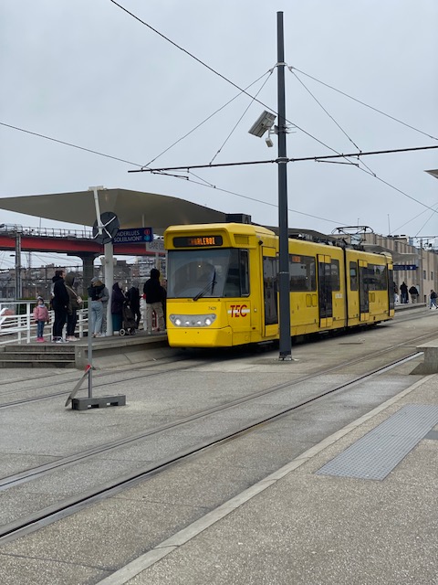
The Métro Léger de Charleroi (MLC) is a 33-kilometre light rail network in Greater Charleroi. The system consists of a loop line around central Charleroi and three branches towards the suburbs of Gilly, Anderlues and Gosselies. Another branch to Châtelet (historically, the third one) was partially built, never entered service, but will finally do so in 2026.
The current system was opened in seven phases ranging from 1976 to 2012, which included 28 stations, of which 24 were in service as of 2012 along with six regular tram stops in Anderlues. On 22 June 2013, 18 more stations were added to the metro system when line M3 to Gosselies went into service.
The original plans for the network were much more extensive with eight branches radiating from the central loop, but had to be abandoned due to high costs and low prospective ridership rates.
The Charleroi metro was planned in the 1960s as a 52 km network, consisting of eight branch lines radiating from a central downtown loop and no less than 69 stations. If completed as planned, this would have been the largest metro system in the Benelux.
In the 1960s, Charleroi already had an extensive tramway network, operated by both SNCV and STIC, but trams were starting to be replaced by buses as those were supposedly more flexible, were cheaper to operate and were perceived as more modern. The metro network was meant to offer trams a second life by providing a fast and comfortable mass transit system, while removing them from the street.
Full completion of the initial project was envisioned between 1992 and 1994. As a general rule, plans called for tracks to be at ground level, on dedicated infrastructure (separated from the street). If not possible, priority was given to viaducts, and tunnels were considered as the last option, except in Charleroi downtown or in densely populated areas.
The first section opened on 21 June 1976, between Sud and Villette, which was the first metro station in Belgium to be built on a viaduct. These were served by what would eventually become line 89 of the original light metro system.
2008 and 2009 saw the resumption of metro construction, following a 75 million euro loan from the European Investment Bank, out of a total estimated cost of 150 million euro.
The finished downtown loop was put in service on 27 February 2012 with the completion of the Sud to Parc section. The same day saw the opening of the Soleilmont extension of the Gilly branch. The completion of the downtown loop involved a comprehensive reorganization of the lines and the introduction of new numbers (M1, M2 and M4) and colors, and the inauguration of the now the metro.


A visit
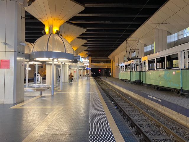
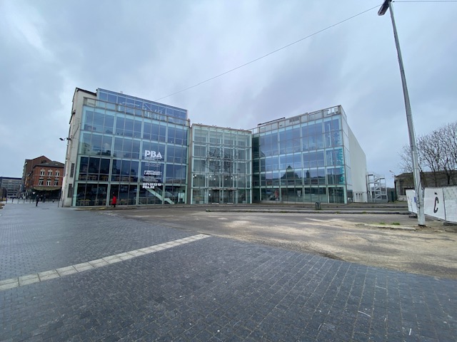
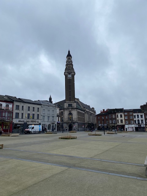
We visited Charleroi on 29 February. Wanting to try out the metro, we took a metro / tram to Palais station. From there we walked to Place Charles II with the Charerloi City Hall with its UNESCO recognized belfry, the Palais des Beaux-Arts or Palace of Fine Arts and and Saint-Christophe de Charleroi church nearby.
St. Christopher’s of Charleroi combines 18th century and 20st century brutalist architecture.
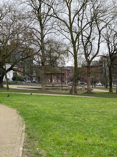
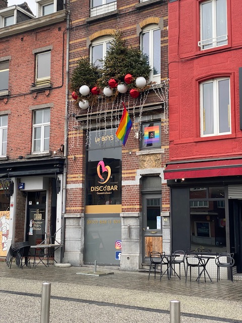
We then walked towards Parc Reine Astrid (Queen Astrid Park) and the Place de la Digue with its recently opened gay bar Le Boys.
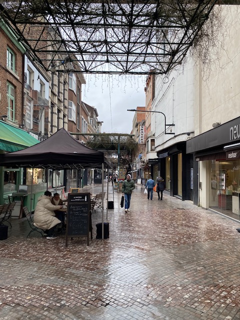
We were looking for places to have lunch. Our first impressions of Charleroi could only confirm our prejudices of Charleroi being quite desolate and faded glory. But walking further towards Boulevard Joseph Tirou, we saw more activities. Shops, restaurants, the Rive Gauche shopping mall and the Place Verte.
After lunch at Kamen Kitchen, we decided to head home though. The weather wasn’t that inviting to roam further and we had still a little trek to do. Because yes, this time, we could sample the Charleroi – Fleurus – Court-Saint-Etienne – Ottignies – Heverlee -Leuven service.


So?
On one hand, you can tell Charleroi’s glory days are over, but you can see efforts are made to boost the city and city activities. I’m sure we could spend more time there. There are the museums, themed walks such as the comic strip walk and so on…

A comprehensive account of a city I don’t know. Could I reblog it Timothy, with a little adaption?
LikeLiked by 1 person
Thank you Denzil.
Sure, have a go. 😀
LikeLiked by 1 person